Development 1821-1925
Key Dates in the Development of Hyde Park Area
1821 Missouri granted statehood — 1825 Treaties with Osage and Kansa cede and relinquish lands — 1831 First tract of land that would become the future Hyde Park Neighborhood sold by state (see Missouri Land Sales in this page’s Supplementary Information) — 1833-1860 Westport becomes boom town with Indian and Santa Fe trade — 1857 Westport incorporated and includes land from State Line to Woodland and Springfield St. (31st Street) to Brush Creek — 1882 First of 35 subdivisions named and platted for future development of Hyde Park area —1887 Hyde Park the park created — 1899 Westport annexed by Kansas City — 1899 Land for Armour Blvd (former Commonwealth Ave) acquired — 1901 Armour Blvd completed to boulevard standards — 1903 Land from 31st to 46th streets acquired for Gillham Rd parkway — 1903 Harrison Blvd from Armour Blvd to near 38th St acquired — 1903 Linwood Blvd from Gillham Rd to Troost acquired — 1906 Last subdivision platted and named — 1906 Harrison Blvd completed — 1906 Linwood Blvd completed from Gillham Rd to Troost — 1907 Gillham Rd from 31st to 46th streets completed — Late 1910s - Early 1920s Luxury apartment hotels and three story apartment buildings - many colonnaded - appear — 1914 Manheim Rd from Holmes to Campbell placed under park board control — 1925 Tuttle-Ayers-Woodward Atlas shows almost all lots are built upon
Survey, Plat and Sanborn Fire Insurance Maps
Historic maps enable us to observe the evolution of a property, as well as visualize the community. They show how land was used over time. Types of maps that are the most useful are survey & plat maps that may show boundaries, ownership, building locations and sizes, streams and railroad tracks. And the Sanborn Fire Insurance Maps that usually include everything in survey and plat maps but also label building materials (wood, brick, stone, etc.). By studying maps over time, a range of dates of when a building was constructed can be determined.
1891
1896
1909 Sanborn Fire Insurance Maps
1925

KCMO Annexation Map

2023 Aerial Map
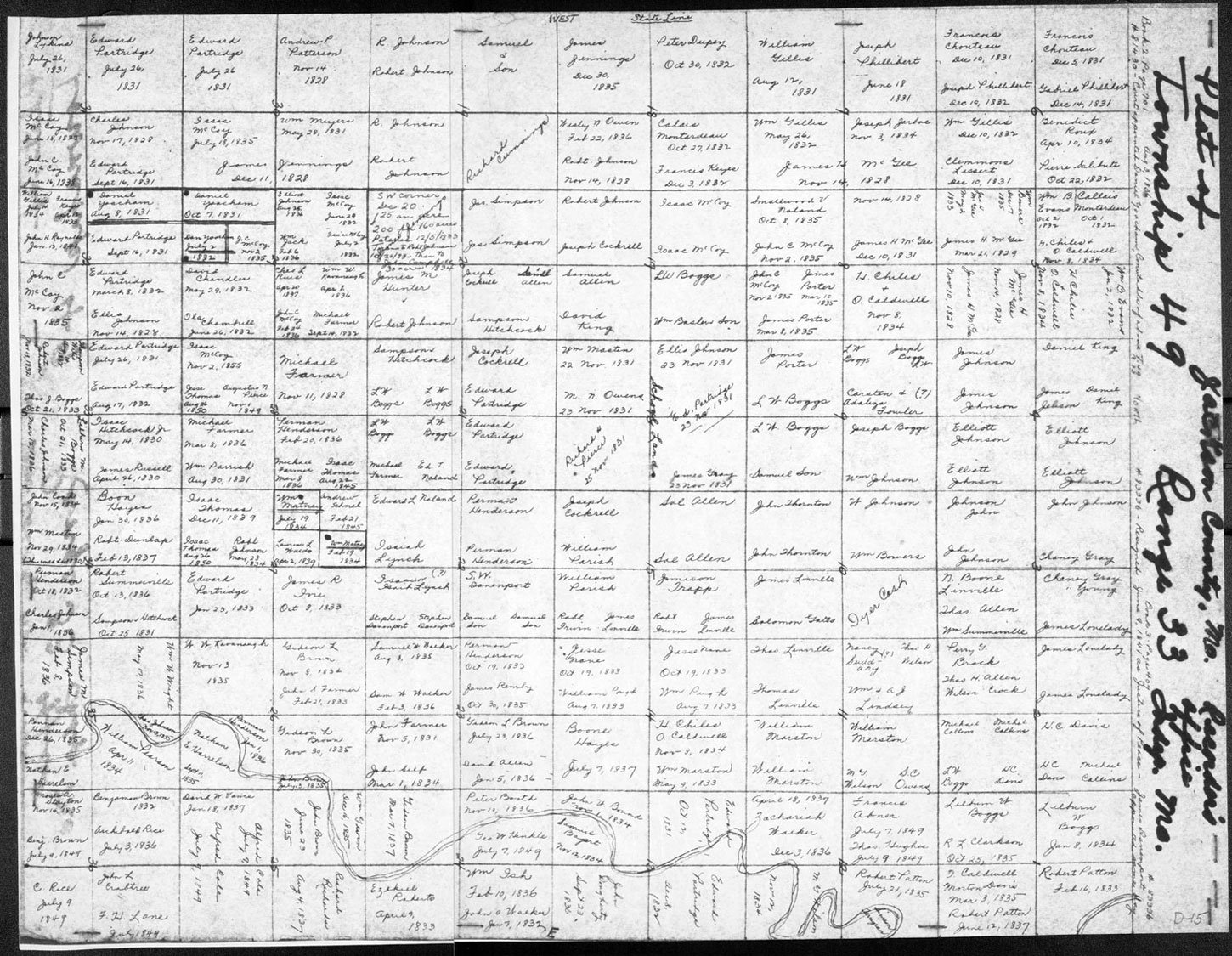
1841 Plat Map - Township 49 Range 33 - Westport
1877

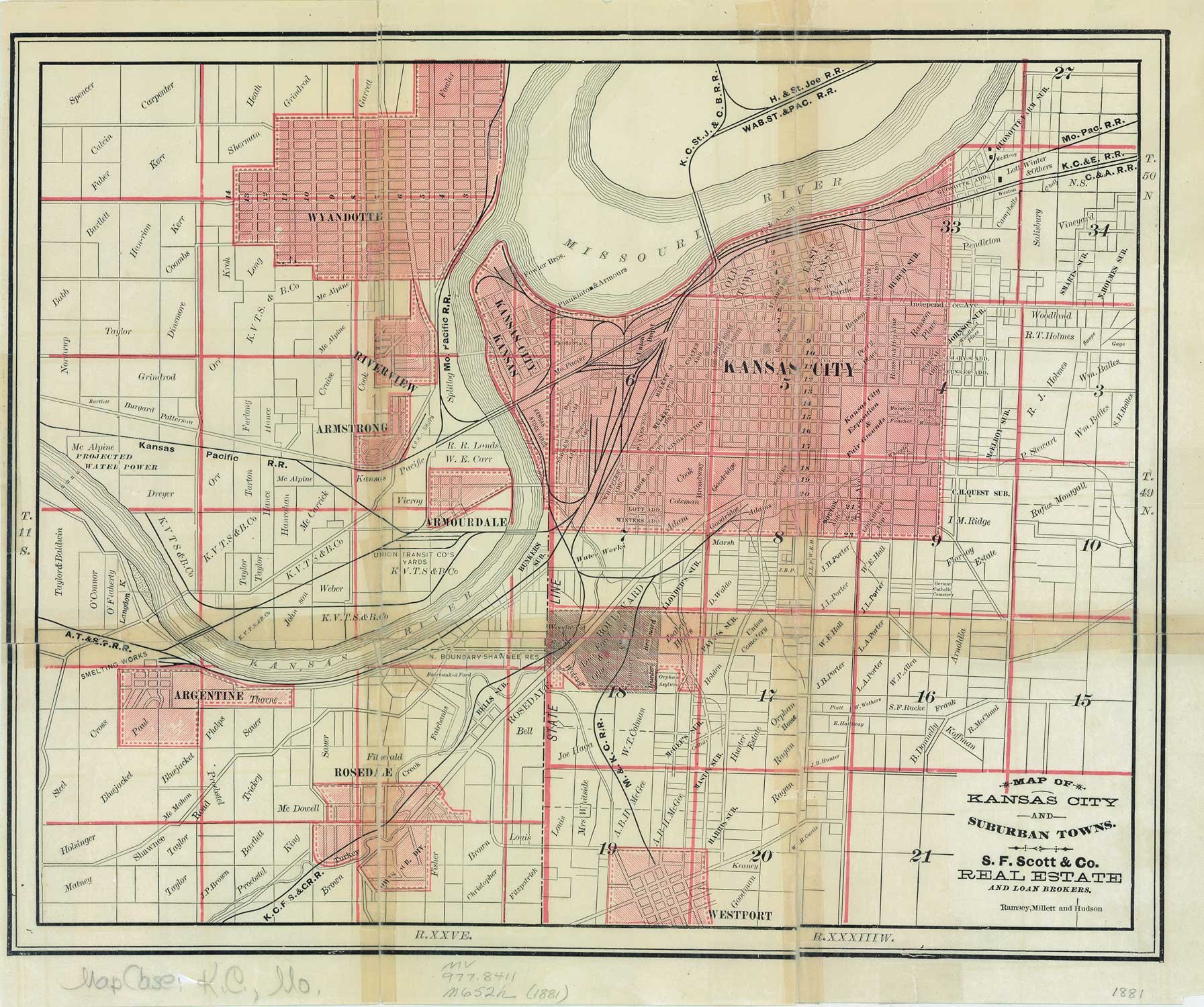
1881 Map of Kansas City & Suburban Towns
1887


Supplementary Information
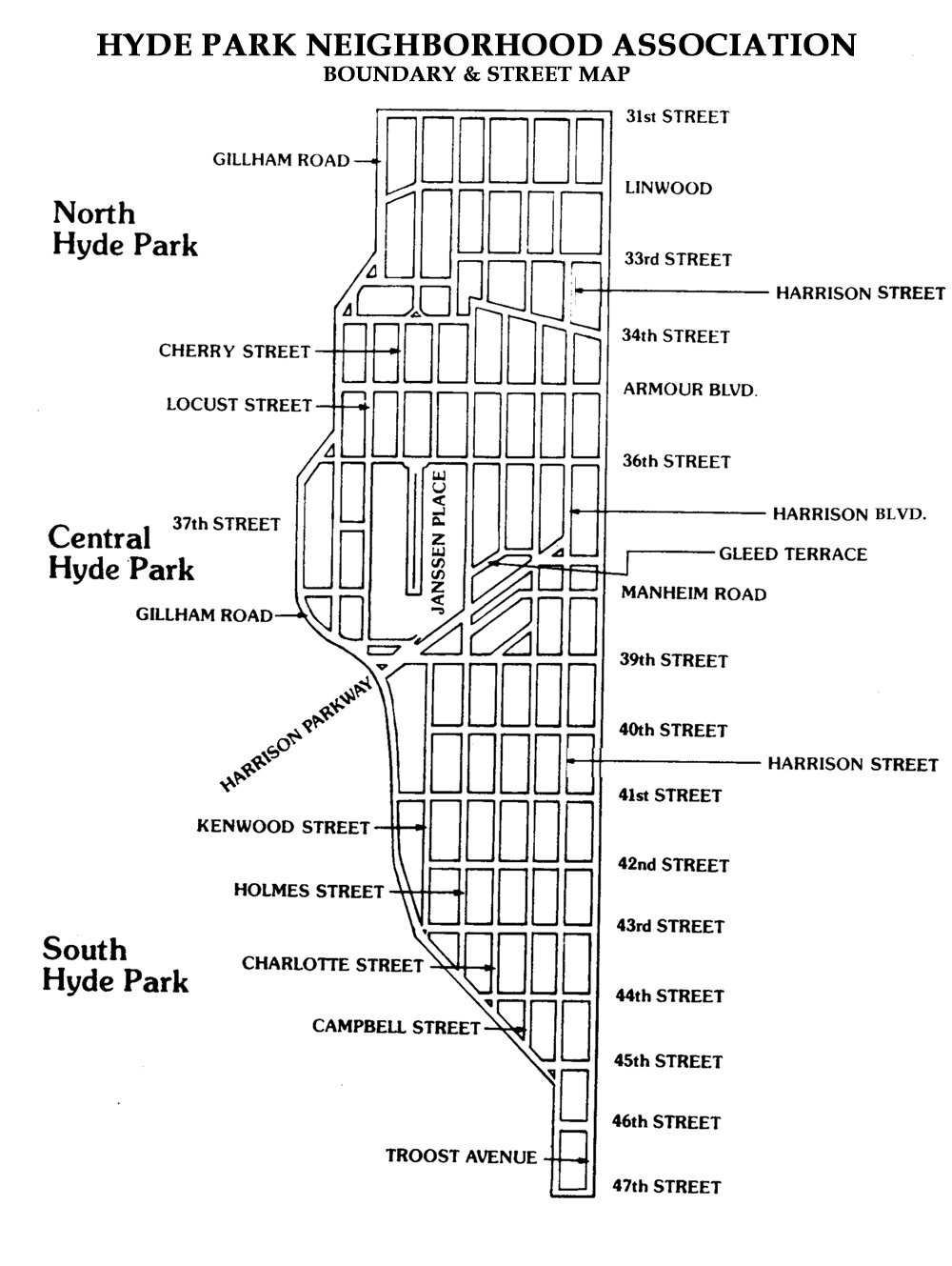
Hyde Park Neighborhood
-
Missouri was a public-domain state where unclaimed land was surveyed, then granted or sold by the government through federal and state land offices. The federal government gave Missouri the land in each sixteenth section in every survey township in the state to benefit public education in the various counties. The land was sold, with profits going to build schools and/or pay teachers. This land was authorized to Missouri in the Act of Admission to the United States. The first sale of a piece of land from the government was called a land patent and the first owner of the land was called a patentee. Later, when the land was sold or mortgaged by private owners, the document was called a deed. The first federal and state transactions were recorded and the paperwork kept at the federal and state level, while all future transactions were recorded at the office of the county register of deeds.
-
The Hyde Park Neighborhood is located in sections SE 17, NE 20, SE 20 and NE 29 in Township 49 Range 33.
SE 17 – between McGee and Oak and Gillham Rd to Troost - 31st St to Armour Blvd
NE 20 – Gillham Rd to Troost Ave – Armour Blvd to 39th St
SE 20 – Oak St to Troost Ave – 39th St to 43rd St
NE 29 – Oak St to Troost Ave – 43rd Street to Emanuel Cleaver II Blvd
-
1831 — SE 17 – West half 80 acres $2.00 per acre Samuel Allen
1831 — SE 17 - East half 80 acres $2.00 per acre Daniel King
1833 — NE 20 - NW quarter 40 acres $1.25 per acre Samuel Allen
1834 — NE 20 - SW quarter 40 acres $1.25 per acre Joseph Cockerel
1833 — NE 20 - East half 80 acres $1.25 per acre Sampson Hitchcock
1833 — SE 20 – East half 80 acres $1.25 per acre Robert Johnson
1835 — SE 20 - West half 80 acres $1.25 per acre James M. Hunter
No Records — NE 29
-
Subdivision Names by Bill Worley August 1981 Hyde Parker, reprinted with the permission of the author.
The Hyde Park neighborhood contains a wealth of colorful names in the 35 different subdivisions that make up the area. Several bear the names of the people who owned the land when it was subdivided. There is Chellis and Dudley's First Addition in north Hyde Park, for example. Edward Chellis and Edward G. Dudley had high hopes for their first venture into the real estate game in 1885. One searches in vain, however, for their second addition.
Other subdivisions named after the land owners include Chadwick's (subdivision plan filed in 1882), Geirge's Addition (1888), Hingston Grove (1887), Hunter Place (1887), Irwin and Morrill Addition (1886), Laforces' Subdivision (1888), McIntyre Place (1891), and the ever popular Woods, Waller, and Holtz's First Addition (1905) and Tate Park (1904) in south Hyde Park. The above subdivisions planned in the 1880s and 1891 are all in north Hyde Park, the first developed area in the Hyde Park neighborhood.
Often subdividers tried to lend an air of class in their developments through their choice of names. The two best known upper income suburbs of Chicago in the 1880s were Hyde Park and Kenwood. The first name was used in Kansas City by the developers of land west of today's Hyde Park neighborhood. The portion of central Hyde Park straight east of Hyde Park park (pardon the redundancy) was given the second name.
Other subdivisions bearing similar "high falooting" names include: Glenairy Place (1900), Hampden Place (1887), Hampden Parkway (1906), Highgate (1888), Kenwood Annex (1887), Lansdowne (1887), Mt. Pleasant (1887), Regents' Park (1887), Vanderbilt Place (1886), and Worcester Park (1886).
Note the English place names in these attempts at evoking exclusivity. Janssen Place was named for the Dutch financial backer who loaned Arthur Stilwell money to build the K.C. Southern railroad.
Another common pattern was to name the subdivision after a main street which bordered or ran through it. The already mentioned Troost Avenue Heights (1887) is an example. Others of this type include Harrison Boulevard Place (1905), Linwood Avenue Heights (1888), Springfield Place (1885—31st Street was originally Springfield Avenue), Troost Avenue Park (1886), and Troost Highlands (1885).
Finally, there are subdivisions with neat names for which there is no apparent rhyme or reason behind the choice. These include Arcade Place (1887), Edna Place (1887), Logan Place (1887), Nicolett Place (1886), Neisho (1906), Sunny Slope (1902, although it can be argued that this is an early example of the use of geographical terrain to determine the name), and Tullis Park (1887).